Australia’s vast marine jurisdiction demands cutting-edge hydrographic survey technology, and the industry is responding with a wave of innovation. From autonomous USVs to quantum navigation, the sector is rapidly evolving to meet the challenges of mapping the world’s largest marine estate.
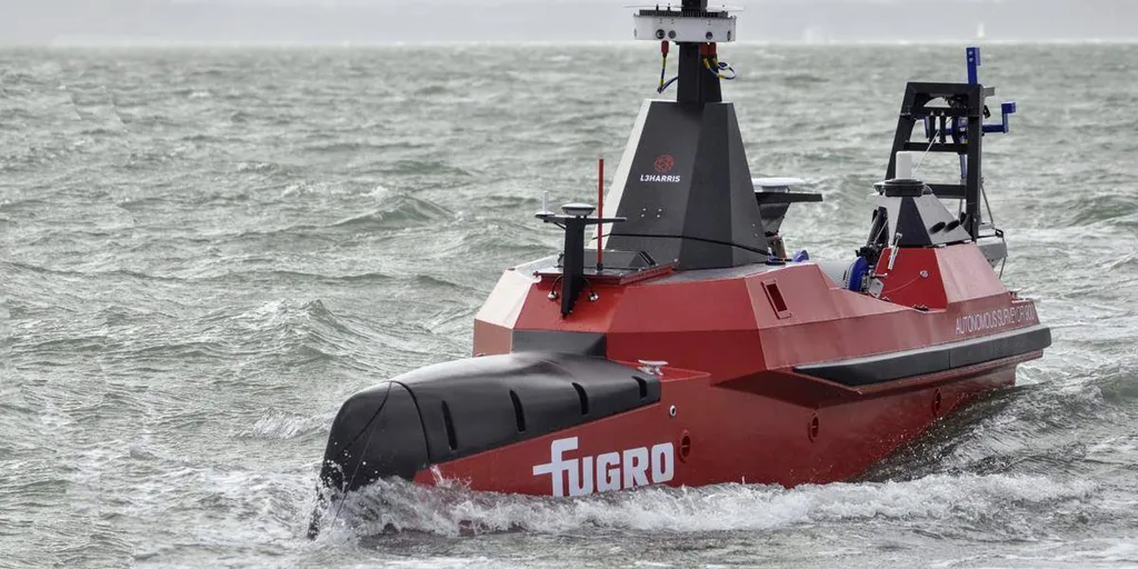
Peter Baker, Director of Growth at Greenroom Robotics, highlights the critical need for advanced survey technology. “Hydrographic survey is very critical for a country like Australia, and we’re not keeping up with the pace of demand of having key areas mapped,” he says. Greenroom Robotics offers a software solution for autonomous navigation, enabling unmanned surface vessels (USVs) to undertake complex survey missions autonomously. The company’s GAMA autonomy system recently powered the successful deployment of the USV Fremantle 01, which mapped over 1,900 km2 of seabed in high resolution during a 42-day mission off the coast of Western Australia. The vessel operated through rough conditions, including swells of up to 5 meters and winds exceeding 30 knots, demonstrating the robustness of autonomous systems in challenging environments.
The adoption of autonomous systems in Australia’s maritime domain is gaining momentum. Baker notes, “We’re seeing much wider acceptance and adoption of autonomous systems.” This trend is not only improving the accuracy of hydrographic surveys but also dramatically reducing fuel consumption, making operations more sustainable and cost-effective.
In October 2024, Geoscience Australia committed to providing data to Seabed 2030, supporting global efforts to compile seabed mapping data into a seamless digital map of the world’s ocean floor. This includes data from the AusSeabed initiative, which aims to coordinate and prioritize seabed mapping efforts across Australia. Lachlan Hurst, spatial development lead at FrontierSI, received the Hydrographic Excellence Award for his involvement in AusSeabed. Hurst emphasizes the importance of coordinated efforts in seabed mapping. “Sending a vessel out to capture this data is expensive, so it’s absolutely critical to understand where the priority areas are, who needs the data, and what types of data need to be collected in order to maximize value,” he says.
In New Zealand, WASSP Ltd offers a multibeam sonar solution that is widely adopted in hydrographic and survey operations. The WASSP S3pr integrates easily with small vessels, providing wide swath coverage, real-time 3D seabed mapping, and efficient shallow-water performance. Haydon Webster, Regional Sales Manager at WASSP, notes, “WASSP multibeam solutions are operating in over 40 countries. Over the last three years, we’ve seen growing demand from the hydrographic sector due to WASSP’s performance and price.”
The Bay of Plenty Regional Council in New Zealand has implemented the WASSP S3pr system for coastal monitoring, gaining full multibeam coverage that produces a detailed, continuous view of the seabed. This technology is not only used for bar soundings but also for monitoring channels and waterways, guiding the strategic placement of navigation aids, and investigating reported underwater obstructions.
Bay Dynamics NZ designs and manufactures custom ROVs and USVs for customers worldwide. Matthew Mooney, Director and Founder of Bay Dynamics NZ, highlights the company’s innovative work in developing hybrid autonomous ROV/AUV systems. “We started doing this custom build work in 2019 on a project for the University of Indiana, funded by the US Navy, to develop a hybrid autonomous ROV/AUV that could self-navigate and avoid in-water objects on its own,” he says. The company is currently working on a custom ROV for an oil and gas client and a research ROV for the University of Waikato, which will be used for under-ice research in Antarctica.
In Australia, a collaboration between Advanced Navigation and marine consultancy O2 Marine saw three Hydrus AUVs deployed to capture high-resolution, geo-referenced imagery and video of the Hall Bank reef site in Western Australia. Dr. Alec McGregor, a senior AI engineer at Advanced Navigation, notes the importance of adding more on-board intelligence to AUVs. “As we look towards more deep-sea missions, we are preparing Hydrus to handle challenging environments more effectively,” he says. The integration of AI-driven navigation and adaptive survey behavior allows Hydrus to respond dynamically to unexpected terrains and signal loss.
Quantum navigation is another area of innovation. Australian quantum software company Q-CTRL has demonstrated its software-ruggedized quantum sensing for navigation technology in a major field trial onboard the Royal Australian Navy’s multi-role aviation training vessel, MV Sycamore. Quantum navigation promises a robust and reliable GPS backup that cannot be jammed or spoofed. Quantum sensing leverages the physics of light and matter on the smallest scales to enable the detection of tiny signals, providing long-term stability essential for various applications.